Ascent 475m
Descent 468m
During our North Downs way walks last year, and even for the Medway Valley jaunts in January/February 2008, we have been pretty lucky with the weather. I guess our luck had to run out sometime! The weather forecast for today was pretty awful, and it was indeed raining lightly (or rather drizzling) on the journey to our meet point at Arlington.
Despite the forecast, eight of us were present and correct at roll call (me, Sally, Anne with Zuka, Dave, Maria, Tim, Val and Chris). I left Becky dog behind because of the bad weather - probably not good for her to be wet and cold all day at her age (15). Derek & Adeloa/Daniel had previous engagements, so they could not attend, and Simon has yet to come out of hibernation.
Taking two cars to Eastbourne, I was surprised at how busy the seafront was, and it took a few moments to find parking. We walked back to the pier which was the official start point (although there was no sign to that effect) and accosted a passer-by to take a full group photo to mark the occasion. Setting off westwards along the promenade it was a wee bit tempting to forget the walk entirely and spend the day in the pier side chip shop or cafe. The sea was grey, the sky was grey - in fact the only things adding colour to our day were Val & Sally in their colourful waterproofs! However, we are made of sterner stuff, so made out way westwards along the prom.
On the car journey to Eastbourne I finally solved the mystery regarding the first section of the Way. According to the OS maps it looked as though the route did a long loop out to Beachy Head and back, which I thought seemed a bit daft. Reading an old guide book of Dave's in the car, however, showed that there were actually two alternative start points - one at the pier and one at Beachy Head, so we were immediately able to abandon the loop, and cut a couple of miles off our intended journey (not a bad idea in this weather).
A Pathway to Health runs for three and a half miles along the front with signs at regular intervals to encourage the locals to exercise - in 2003 the distance signs were changed from km to miles at the request of local residents (I guess most of Eastbourne's residents are of a certain age where kilometres don't mean a lot, but even our group prefers to measure progress in the old imperial form, hence the strange mix in our walk statistics of distances in miles, but ascent in metres). There are also a number of sculptures along the Pathway, including one by Jackie Brown called 'taking a stone for a walk'.
Zuka spent much of her time along the prom looking longingly at the beach - I'm sure she could smell all sorts of delectable things down amongst the pebbles (discarded burgers, dead fish? YUM YUM!).

The ascent up the Downs - that ice cream should be big enough even for Anne!

Anne catches her breath and looks back towards the pier
Towards the end of the promenade we climbed back up to the road and finally left the tarmac at the start of the South Downs Way footpath section, where the path climbed steeply to the top of the downs.
We soon parted company temporarily with the SDW and swung west and then north west across the springy turf. There was quite a strong wind blowing for a while, but fortunately the wet stuff was still only drizzle, and as we were walking on downland turf, it was pretty dry underfoot. We were now high above the houses on the western fringes of Eastbourne, and we could just about make out the pier behind us though the gloom and mist.
Reaching a trig point and dew pond, we took a quick breather and ticked off our first 'top'. Val realised she had lost one of her gloves (which had been purchased in Austria, so it was a bit far to go back to buy a new one). It was odd that no one walking behind Val had spotted it on the ground - what an unobservant lot we are - perhaps we were enjoying the far reaching views instead (not). Despite a brief search by Dave & Chris, it was unfortunately not recovered.
We now joined up with the SDW bridle path section, and after a brief scramble down a slope, crossed the A259 (Maria sensibly took the correct route without the scramble). Continuing beside Eastbourne golf course, we continued along the top of the scarp, heading for Willingdon Hill. To our left (SW) we passed a succession of dry valleys with wonderful names like Crapham Bottom and Crunden's Bottom.
As we looked south westwards there appeared to be a slight glimmer of light above Birling Gap, and we could just make out the Belle Tout light house (although you cannot reliably make it out in the photo below). This light house, that likes to live life on the edge, has this month (March 2008) been sold to a private buyer, much to the disappointment of the Lighthouse Preservation Trust which was a not-for-profit organisation formed with the sole aim of buying, preserving and opening the building to the public. I guess it just took too long to raise the necessary funds.
Along this section the route followed farm tracks. Due to the wet weather these were pretty flooded and it was necessary to walk on the grass alongside the tracks themselves.
Shortly after passing the trig point on Willingdon Hill (201m), we said goodbye to the SDW again, now accompanying the 1066 Country Walk past Butts Brow car park and round Combe Hill.
Near the car park I had a bit of trouble squeezing through a narrow kissing gate - I've obviously given up on the diet a bit prematurely! The way then continued through a herd of chilled out Sussex cattle. Along this next section the mist really came down and visibility dropped to a few hundred meters.
Finally, we began the descent down to Jevington, where the now legendary Banoffee Pie was apparently invented at the Hungry Monk restaurant. On this miserable day however, it was The Eight Bells pub that tempted us to linger, but we pushed on through the village, looking for a possible site to stop for a damp picnic.
We found a suitable spot just after leaving the village, on a bank under a large tree. To her horror, Anne realised she had left her sandwiches in the car. Refusing a share of my (very nice) Covent Garden Leek & Potato soup, I gave up my Snickers bar (but only because Dave had very kindly provided chocolate at the start of the walk, and so I had already eaten a Mars!). Dave took a quirky photo in the field next to our lunch spot - I think he was the only one who spotted them. They seem to be fishermen of some kind, but goodness knows what they were doing there.
Muddy bridleway leaving Jevington
The route now climbed slowly back up the Downs, along unpleasantly muddy, enclosed bridleways. I'm sure they seem much nicer on a warm, sunny summer day, when I expect people are glad of a bit of shade. We did come out into the open a couple of times - at Cranedown Bottom and at the tiny hamlet of Folkington, where there was a simple flint-built downland church.
After a little more climbing (and a lot more mud), we emerged back on the open downland, about half way up the scarp. Zuka, hot on the scent of rabbits, bounded up and down the steep hill, making us marvel at her energy!
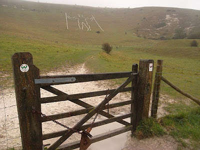
Our route, still rather slippery and muddy in places, took us to the base of the Long Man of Wilmington, on Windover Hill. There are many theories concerning this large white figure, but in view of the weather, we didn't linger to chat, but rather made our way north and down towards Wilmington village itself. See link for for info on the Long Man http://www.sussexpast.co.uk/property/site.php?site_id=13
The Long Man of Wilmington (complete with walking poles)
After half a mile or so of road walking we ventured cross country again across a number of damp fields climbing stiles at most boundaries. Emerging on a minor road, we turned north again to risk life and limb crossing the busy A27 - the noise from which had been evident for some time.
North of the trunk road, we hit a bit of horrible weather. High winds were blowing the heavy drizzle straight into our faces, and it was quite tiring to battle through the tussocky grass. I was towards the back, head down, following like a lemming, and was therefore unfortunately out or earshot to hear Anne's concerns regarding our direction of travel - she had seen a stile over to our left and wondered if we should be heading for it. Eventually, I realised there was a problem up front and a quick glance at the GPS confirmed we were some distance off track. This meant walking round the perimeter of the field back to the stile Anne had previously seen - oh dear, just what we needed today (not)!
Back on track we continued north, over more stiles to cross the railway. Poor Maria, who finds stiles a bit tricky, was beginning to feel a bit the worse for wear on this latter section of the walk -she has since admitted that the problem with her leg stems from an accident a few years back when she was celebrating (rather too enthusiastically it would appear) the success of the England rubgy team in the World Cup (oops!). Some of the stiles were really quite hazardous in the wet, being very slippery, and you really had to be careful how you placed your feet. The ones either side of the railway however, were much better, as they had a non-slip surface (looked like roofing felt to me) attached to the step surfaces.
River Cuckmere
Crossing several more fields (and the inevitable stiles - at least most were comparatively dog friendly), our route converged with a rather brown and unattractive section of the River Cuckmere, which we followed for a while before crossing a minor road which is along the line of a Roman road from Pevensey to Selmeston. The bridge over the river here was currently being repaired, which had resulted in the road being closed.
Stiles.........
......and more stiles
Although the weather was not particularly pleasant today, in view of the forecast for heavy rain, I think we got away pretty lightly. Waterproof coats and trousers had kept us all pretty dry. My feet were a little bit damp by the end, but then my walking boots are pretty ancient (I must get round to breaking in the new ones before the next stage). Sally, Val & Maria were all pretty mud caked - I seem to escape the gradual spread of mud up the inside of my legs; must be the wide childbearing hips!).
Entering Arlington village
So that's Stage 1 complete. Had the weather been kinder, the views (particularly on the South Downs) would have been really fantastic. If the sun is shining when you do this section, Derek, perhaps we'll all join you and walk it again.


1 comment:
The Quirky Fishermen grace a jump called the Fisherman's Leap by the large lake at Firle Place Horse Trials and Country Fair every last Sunday in August! Imagine my surprise to find them on your web site - but I am glad they enlivened your walk!!
Post a Comment